Order Total (1 Item Items):
Shipping Destination:

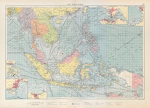
East Indian Port Inset Rangoon by Philip George (2 results)
Feedback
Skip to main search results
Search filters
Product Type
- All Product Types
- Books (No further results match this refinement)
- Magazines & Periodicals (No further results match this refinement)
- Comics (No further results match this refinement)
- Sheet Music (No further results match this refinement)
- Art, Prints & Posters (No further results match this refinement)
- Photographs (No further results match this refinement)
- Maps (2)
- Manuscripts & Paper Collectibles (No further results match this refinement)
Condition
- All Conditions
- New (No further results match this refinement)
- Used (2)
Binding
- All Bindings
- Hardcover (No further results match this refinement)
- Softcover (No further results match this refinement)
Collectible Attributes
- First Edition (No further results match this refinement)
- Signed (No further results match this refinement)
- Dust Jacket (No further results match this refinement)
- Seller-Supplied Images (2)
- Not Print on Demand (2)
Language (1)
Price
- Any Price
- Under US$ 25 (No further results match this refinement)
- US$ 25 to US$ 50 (No further results match this refinement)
- Over US$ 50
Free Shipping
- Free Shipping to U.S.A. (No further results match this refinement)
Seller Location
Seller Rating
-
East Indian Port inset Rangoon; Singapore Island; Singapore; Jakarta; Hong Kong Harbour; Manila Bay
Publication Date: 1952
Map
Condition: Good. East Indies Ports sea chart. lighthouses mail routes. Indochina. LARGE 1952 map. Antique colour maritime map chart; George Philip & Son Ltd (1952). 49.0 x 69.0cm, 19.25 x 27 inches; this is a folding map. Condition: Good. There is nothing printed on the reverse side, which is plain.
-
East Indian Port inset Rangoon; Singapore Island; Singapore; Jakarta; Hong Kong Harbour; Manila Bay
Publication Date: 1959
Map
Condition: Good. East Indies Ports sea chart. lighthouses mail routes. Indochina. LARGE 1959 map. Antique colour maritime map chart; George Philip & Son Ltd (1959). 49.0 x 69.0cm, 19.25 x 27 inches; this is a folding map. Condition: Good. There is nothing printed on the reverse side, which is plain.