Order Total (1 Item Items):
Shipping Destination:

Memalik: Books, Used (18 results)
Feedback
Skip to main search results
Search filters
Product Type
- All Product Types
- Books (18)
- Magazines & Periodicals (No further results match this refinement)
- Comics (No further results match this refinement)
- Sheet Music (No further results match this refinement)
- Art, Prints & Posters (No further results match this refinement)
- Photographs (No further results match this refinement)
- Maps (1)
- Manuscripts & Paper Collectibles (No further results match this refinement)
Condition
- All Conditions
- New (No further results match this refinement)
- Used (18)
Binding
Collectible Attributes
- First Edition (7)
- Signed (No further results match this refinement)
- Dust Jacket (1)
- Seller-Supplied Images (15)
- Not Print on Demand (18)
Language (4)
Price
- Any Price
- Under US$ 25 (No further results match this refinement)
- US$ 25 to US$ 50
- Over US$ 50
Free Shipping
- Free Shipping to U.S.A. (No further results match this refinement)
Seller Location
Seller Rating
-

Condition: As New. THIS IS NOT AN ORIGINAL COPY. IT IS A PHOTOCOPY OF THE TITLE, BOUND IN BOOK FORMAT Editors: Translator: 100 pages.
-
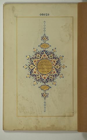
[Collection of treaty articles relating to commercial transactions of subjects of the Austrian state in the Ottoman Empire]. Avusturya devleti tebaasinin Memalik-i Osmaniyede ticaretlerine ait mevadd-i ahdiyye mecmuasidir.
Published by Dar tiba' al-imberaturiyy (k. k. Hof- und Staatsdruckerei),, Vienna,, 1846
Seller: Antiquariaat FORUM BV, Houten, Netherlands
Seller rating 2 out of 5 stars

The full text of 19 trade treaties, in Ottoman Turkish throughout, closed between the Austrian and the Ottoman Empire between 1110/1699 (Peace of Karlovac) and 1259/1844. Bound in the same volume is the 1844 Italianlanguage edition, containing the texts of the various treaties in their respective original European language, with an Italian translation on the opposite pages.Ownership "C Fr Jelinek 1855" signed to endpaper. The Turkish text shows occasional insignificant foxing, as common; altogether very well preserved. A splendidly bound copy.l Zenker, BO II, 805. Contemporary green morocco binding with fore-edge flap, covers giltstamped with an oriental design. All edges gilt. Printed in black with red headings, within printed gilt rules. Illuminated head-piece and 'unwan printed in three colours and gilt, in imitation of manuscript illumination. Gilt tail-piece. Pages: 88; [4], VIII, 224 pp. With: Raccolta dei trattati e delle principali convenzioni concernanti il commercio e la navigazione dei sudditi Austriaci negli Stati della Porta Ottomana. Vienna, Dar tiba' al-imberaturiyy (k. k. Hof- und Staatsdruckerei), 1844.
-
[Collection of treaty articles relating to commercial transactions of subjects of the Austrian state in the Ottoman Empire]. Avusturya devleti tebaasinin Memalik-i Osmaniyede ticaretlerine ait mevadd-i ahdiyye mecmuasidir.
Published by Dar tiba' al-imberaturiyy (k. k. Hof- und Staatsdruckerei),, Vienna,, 1846
Seller: ASHER Rare Books, T Goy Houten, Netherlands
Seller rating 4 out of 5 stars

The full text of 19 trade treaties, in Ottoman Turkish throughout, closed between the Roman/Austrian and the Ottoman Empire between 1110/1699 (Peace of Karlovac) and 1259/1844. An Italian-language edition had appeared in 1844 ("Raccolta dei Trattati e delle principali convenzioni concernanti il commercio e la navigazione dei sudditi Austriaci negli Stati della Porta Ottomana").Occasional insignificant foxing; altogether very well preserved. A splendidly bound copy.l Zenker, BO II, 805. Printed in black with red headings, within printed gilt rules. Illuminated head-piece and 'unwan printed in three colours and gilt, in imitation of manuscript illumination. Gilt tail-piece. Pages: 88 pp. With:(2) Raccolta dei trattati e delle principali convenzioni concernanti il commercio e la navigazione dei sudditi Austriaci negli Stati della Porta Ottomana.Vienna, Dar tiba' al-imberaturiyy (k. k. Hof- und Staatsdruckerei), 1844.
-
Mem�lik-i Osm�n�ye cep atlasi. Devlet-i `Aliye-i Osm�n�yenin ahv�l-i cografya ve istatistikiyesi.
Published by Istanbul, Ibrahim Hilmi, [1907 CE =] 1323 Rumi., 1907
Seller: Antiquariat INLIBRIS Gilhofer Nfg. GmbH, Vienna, A, Austria
Association Member: ILAB VDA VDAO
Seller rating 5 out of 5 stars

First Edition
Small 8vo. 8, 328 pp. With 64 colour lithographed plates of maps and diagrams. Original light brown cloth bearing elaborate Ottoman Art Nouveau designs. This edition of Hilmi's "Pocket Atlas" captures the Ottoman Empire during the twilight of the Hamidian Era, when it still controlled territories on three continents, extending from Albania to Yemen. With 64 highly attractive colour lithographic plates, the atlas features an especially extensive collation of thematic maps and diagrams, more that we have encountered in other issues, including detailed maps of the empire's various vilayets. Notably, the book's coverage of the Arabian Peninsula is excellent, with a double-page map of the entire peninsula; a custom map of the route of the Hejaz Railway (due to be extended as far south as Medina in 1908); a map of the Basra Vilayet (with southern Iraq, Kuwait, Bahrain and Qatar, as well as parts of today's Saudi Arabia); as well as separate maps of Yemen and Asir. - Ibrahim Hilmi Cigiracan (1876-1963) was one of the most important publishers and cartographers of the late Ottoman Empire. Born in Tulcea (now in Romania), he founded his first printing shop in Istanbul in 1896, under the name "Kitaphane-i Islami" (Islamic Library), largely producing religious books. Subsequently, Hilmi became interested in military affairs, geography and history, and changed the name of his press to "Kitaphane-i Islam ve Askeri" (Islamic and Military Library). He published about 200 military books, and his atlases (especially his "Pocket Atlas") were among the most popular cartographic items throughout the empire. During WWI, Hilmi gained the affection of the public for his charitable programme of sending free books to poor children in Anatolia. - Hilmi's enterprise thrived until Atat�rk's Republican regime nationalized the publishing of law and school books in the 1920s, undercutting the most lucrative part of his business. However, Hilmi left an enduring legacy, having published over a thousand books on a wide variety of topics over three decades. - Binding worn with a few chips of minor loss, especially along hinges, but holding firm; old repairs to lower margin of upper cover. Internally light, even toning to text pages and some marginal chips to few leaves and plates, not affecting printed area. Maps generally clean and bright, just some offsetting to 4 maps. A fine edition. - OCLC 1014526531.
-

Avusturya devleti tebaasinin Memalik- i Osmaniyede ticaretlerine ait mevadd-i ahdiyye mecmuasidir.
Published by Vienna, Dar tiba'al-imberaturiyy (k.k. Hof und Staatsdruckerei), 1846., 1846
Seller: Michael Steinbach Rare Books, Wien, Austria
Association Member: ILAB VDA VDAO
Seller rating 5 out of 5 stars
23,5 : 15,5 cm. 88 pages, printed in black with red headings, with printed gilt rules. Illuminated head-piece and 'unwan printed in three colours and gilt., in inmitation of manuscript illumination. Coloured, illustratged original boards. Colletction of treatise relating to commercial transactions of subjects of the Austrian state in the Ottoman Empire. - The full text of 19 treaties, in Ottoman Turkish throughout, closed between the Roman/Austrian and the Ottoman Empire between 1110/1699 (Peace of Karlovac) and 1259/1844. An Italian -language edition had appeared in 1844 ("Raccolta dei Trattati e delle principali convenzioni concernanti il commercio e la navigazione dei sudditi Austriacinegli Stati della Porta Ottomana").
-

Memalik-i Osmaniyye'nin Akt�r-i Simaliyesi Haritasi.
Published by �sk�dar (Istanbul), M�hendishane Matbaasi, [ca 1803]., 1803
Seller: Antiquariat INLIBRIS Gilhofer Nfg. GmbH, Vienna, A, Austria
Association Member: ILAB VDA VDAO
Seller rating 5 out of 5 stars
Engraved map in outline colour, 119 x 53.4 cm. Backed with cloth. One of the earliest monuments of Islamic cartography, of outstanding rarity: published at roughly the same time as the famous "Cedid Atlas", also by the Imperial Engineering School in Scutari (Istanbul), this large-scale engraved wall map shows the "Northern Territories of the Ottoman Empire". This hitherto practically unknown map is clearly to be viewed in connection with the atlas which has long been considered the first and most important achievement of modern Muslim cartography. Like the Cedid Atlas, this outstanding publishing venture was commissioned under the authority of Sultan Sultan Selim III. A pioneering attempt at mapping a substantial part of the far-flung Empire, the map reaches from southern Italy and the Balkans to the Caucasus and the Caspian Sea. The most detailed map of the Empire's Northern Territories available at the time and one of the first wall maps printed in Constantinople. - Occasional unobtrusive professional repairs, well preserved altogether. - Esat Efendi no. 2049. �zdemir, Ottoman Cartography, p. 190f. (illustrated).
-
Avusturya devleti tebaasinin Memalik-i Osmaniyede ticaretlerine ait mevadd-i ahdiyye mecmuasidir.
Published by Vienna, Dar tiba' al-imberaturiyy (k. k. Hof- und Staatsdruckerei), 1846., 1846
Seller: Antiquariat INLIBRIS Gilhofer Nfg. GmbH, Vienna, A, Austria
Association Member: ILAB VDA VDAO
Seller rating 5 out of 5 stars
Large 8vo. 88 pp. Printed in black with red headings, within printed gilt rules. Illuminated head-piece and 'unwan printed in three colours and gilt, in imitation of manuscript illumination. Gilt tail-piece. Contemporary green morocco binding with fore-edge flap, covers giltstamped with an oriental design. All edges gilt. The full text of 19 trade treaties, in Ottoman Turkish throughout, closed between the Roman/Austrian and the Ottoman Empire between 1110/1699 (Peace of Karlovac) and 1259/1844. An Italian-language edition had appeared in 1844 ("Raccolta dei Trattati e delle principali convenzioni concernanti il commercio e la navigazione dei sudditi Austriaci negli Stati della Porta Ottomana"). - Occasional insignificant foxing; altogether very well preserved. A splendid copy bound for the Austrian Imperial printing office. - Zenker, BO II, 805.
-
Avusturya devleti tebaasinin Memalik-i Osmaniyede ticaretlerine ait mevadd-i ahdiyye mecmuasidir.
Published by Vienna, Dar tiba' al-imberaturiyy (k. k. Hof- und Staatsdruckerei), 1846., 1846
Seller: Antiquariat INLIBRIS Gilhofer Nfg. GmbH, Vienna, A, Austria
Association Member: ILAB VDA VDAO
Seller rating 5 out of 5 stars
Large 8vo. 88 pp. Printed in black with red headings, within printed gilt rules. Illuminated head-piece and 'unwan printed in three colours and gilt, in imitation of manuscript illumination. Gilt tail-piece. (Bound with:) Raccolta dei trattati e delle principali convenzioni concernanti il commercio e la navigazione dei sudditi Austriaci negli Stati della Porta Ottomana. Ibid., 1844. (4), VIII, 224 pp. Contemporary green morocco binding with fore-edge flap, covers giltstamped with an oriental design. All edges gilt. The full text of 19 trade treaties, in Ottoman Turkish throughout, closed between the Austrian and the Ottoman Empire between 1110/1699 (Peace of Karlovac) and 1259/1844. Bound in the same volume is the 1844 Italian-language edition, containing the texts of the various treaties in their respective original European language, with an Italian translation on the opposite pages. - Ownership "C Fr Jelinek 1855" signed to endpaper. The Turkish text shows occasional insignificant foxing, as common; altogether very well preserved. A splendidly bound copy. - Zenker, BO II, 805.
-
Mirat �l-memalik. Asar-i eslafdan.
Published by Dersaadet (Istanbul), Ikdam Matbaasi, [1895 CE] = 1313 H., 1895
Seller: Antiquariat INLIBRIS Gilhofer Nfg. GmbH, Vienna, A, Austria
Association Member: ILAB VDA VDAO
Seller rating 5 out of 5 stars
8vo. 99, (1) pp. Red half morocco with blindstamped cloth boards and giltstamped spine title in Ottoman Turkish. First and only edition in the Ottoman world. Sidi Ali Reis was an Ottoman admiral sent by Suleiman the Magnificent to counter Portuguese piracy and attacks on Muslim pilgrim ships in the Indian Ocean, Arabian Sea, Red Sea and Arabian Gulf. He was shipwrecked in India and travelled to the Muslim states of South Asia, Afghanistan, central Asia, Iran, and the Middle East before returning to the Ottoman Empire. His travels are recounted in his present "Mirat �l-Memalik" ("The Mirror of Countries"), first published in 1557, one of the earliest travel books of Turkish literature and written in the now extinct Chagatai language. Rare: OCLC lists 3 copies only internationally (Leiden, Bamberg, Munich). - OCLC 632504491, 65818716.
-
MEMALIK - I OSMANIYEDE KRAL RAKOCI VE TEVABII (1109 - 11549)
Published by KUBBEALTI FOTOKOPI n/a, Istanbul
Condition: As New. THIS IS NOT AN ORIGINAL COPY. IT IS A PHOTOCOPY OF THE TITLE, BOUND IN BOOK FORMAT Editors: Translator: pages.
-
Geschichte Sultan Suleyman Kanunis Von 1520 Bis 1557: Oder Tabakat Ul-Memalik Ve Derecat Ul-Mesalik Von Celalza de Mustafa, Genannt Koca Nisanci. in . Orientalischen Handschriften in Deutschland)
Published by Franz Steiner Verlag Wiesbaden GmbH, 1981
ISBN 10: 3515029117 ISBN 13: 9783515029117
Language: German
Hardcover. Condition: Very Good. 180, approximately 600 pages ; 25 cm. Text in Turkish, commentary in German. 'Edition:In facsimile herausgegeben nach der Handschrift Berlin, Staatsbibliothek Preussischer Kulturbesitz Ms. or. quart. 1961, mit Varianten der Handschriften Wien, Nationalbibliothek H.O. 41, Istanbul, Ayasofya 3206, Fatih 4423, Universite Ktph. T.Y. 5997, Indices, einer Biographie des Autors sowie Untersuchungen zur osmanischen Historiographie des 16. Jahrhunderts'.
-
![Seller image for [MEDICAL MEASURES OF OTTOMAN ARMY IN ARAB COUNTRIES] Mem�l�k-i Harreye sevk edilecek efr�d hakkinda ittihaz edilecek ted�b�r-i sihhiyeye dair talim�t. [i.e. Instruction on medical measures to be taken for soldiers to be sent to the desert in Tripoli War]. for sale by Khalkedon Rare Books ABA, ILAB, IOBA, ESA](https://pictures.abebooks.com/inventory/md/md31493586922.jpg)
[MEDICAL MEASURES OF OTTOMAN ARMY IN ARAB COUNTRIES] Mem�l�k-i Harreye sevk edilecek efr�d hakkinda ittihaz edilecek ted�b�r-i sihhiyeye dair talim�t. [i.e. Instruction on medical measures to be taken for soldiers to be sent to the desert in Tripoli War].
Published by Asker� Matbaa., [AH 1325], Istanbul (Constantinople), 1909
Language: Turkish, Ottoman (1500-1928)
Seller: Khalkedon Rare Books ABA, ILAB, IOBA, ESA, Istanbul, Turkey
Association Member: ABA ESA ILAB IOBA
Seller rating 5 out of 5 stars
First Edition
Soft cover. Condition: Very Good. 1st Edition. Original wrappers. Foolscap 8vo. (17 x 12 cm). In Ottoman script (Old Turkish with Arabic letters). 6 p. First and only edition of this first booklet including fourteen articles on medical measures to dispatch soldiers to the hot regions of Ottoman geography before the Tripoli War in 1910, especially to Palestine, Iraq, Mesopotamia, and Arab countries. Before the Tripoli War, the dispatch of soldiers to the hot regions of the Ottoman geography, to the Arab countries, and to the deserts faced some medical problems. The Ottoman army took some measures to overcome the difficulties encountered due to epidemics and insufficient medical equipment. The fourteen articles in the booklet specify the materials and conditions required to ensure the hygienic and comfortable travel of the soldiers who will be dispatched to the hot regions by ferry and other means. After one year published this military instruction booklet, the Ottoman army would fight not more than 2000 soldiers to be sent to the desert in the 1910 Tripoli War against the 35000 soldiers of the Italian army. When the First World War began, all lands such as Palestine, the Sinai Peninsula, North Africa, Arabia, and Yemen would be lost. �zege 12990.; We can't trace any copy in OCLC.
-
[FIRST BOOK OF THE AGRICULTURAL GEOGRAPHY OF THE OTTOMAN EMPIRE] Mem�lik-i Osmaniye'nin ziraat cografyasi [i.e., Agricultural geography of the Ottoman Empire]
Published by Mihran Matbaasi, Bab-i �li Caddesi'nde No 7., AH 1303 = [1886], Istanbul, 1886
Language: Turkish, Ottoman (1500-1928)
Seller: Khalkedon Rare Books ABA, ILAB, IOBA, ESA, Istanbul, Turkey
Association Member: ABA ESA ILAB IOBA
Seller rating 5 out of 5 stars
First Edition
Hardcover. Condition: Very Good. 1st Edition. Original publisher's cloth. Demy 8vo. (20 x 15 cm). In Ottoman script (Old Turkish with Arabic letters). 60, 175 p. On the rear cover, there's a list including a large number of books published by Dar�ssafaka. Scarce first edition of this first book on agricultural geography of the Ottoman Empire, written for the Agricultural Geography Course of Dar�ssafaka High School given in the sixth and seventh grades of the school. To its maximum extent, the book contains the geography of the Imperial Ottoman in the late 19th century from Europe to Arabia, from Iraq to Africa. The book was written by an Ottoman officer Major Hu?seyin Efendi and it's an important source in terms of a geographical understanding of the agricultural activities in the Ottoman country. The text starts with a description of the administrative and physical divisions of the Ottoman Empire with detailed charts (pp. 5-60) after the introduction (pp. 2-4). The author gives a short information about the relations of geography and agriculture. Then, a detailed account of agricultural species growing in the Imperial geography was given. The Dar�ssafaka High School is a school in Maslak, Istanbul. The school was founded by the Dar�ssafaka Association with the name "Dar�ssafakar'�l Islamiye" in 1873. �zege 13038., TBTK 13854., As of December 2023, the OCLC shows 14 copies; 9 copies are in North American institutes.
-
![Seller image for Avusturya devleti tebaasinin Memalik-i Osmaniyede ticaretlerine ait mevadd-i ahdiyye mecmuasidir. [Sammlung von Vereinbarungen betreffend den Handel und die Schifffahrt der �sterreichischen Untertanen in den Staaten der Osmanischen Pforte]. for sale by Versandantiquariat Wolfgang Friebes](https://pictures.abebooks.com/inventory/md/md31441295526.jpg)
Avusturya devleti tebaasinin Memalik-i Osmaniyede ticaretlerine ait mevadd-i ahdiyye mecmuasidir. [Sammlung von Vereinbarungen betreffend den Handel und die Schifffahrt der �sterreichischen Untertanen in den Staaten der Osmanischen Pforte].
Published by Wien, Hof- und Staatsdruckerei, 1846., 1846
Language: German
Seller: Versandantiquariat Wolfgang Friebes, Graz, Austria
Seller rating 5 out of 5 stars
First Edition
Condition: 0. Pr�chtigen Publikation in der Art einer Handschrift, enthaltend 19 zwischen Wien und der Pforte im Zeitraum von 1110 und 1699 (Friede von Karlovac) geschlossenene Vertr�ge und �bereinkommen betreffend den Handel und die Schifffahrt der �sterreichischen Untertanen in den Staaten der Osmanischen Pforte. Die Vertragstexte in osmanischem T�rkisch. Eine Ausgabe in Italienisch ("Raccolta dei Trattati e delle principali convenzioni concernanti il commercio e la navigazione dei sudditi Austriaci negli Stati della Porta Ottomana") erschien bereits 1844. - Umschlag leicht staubrandig. Schnitt etw. stockfleckig, sonst sch�nes Exemplar. - Zenker, BO II, 805. Sprache: Deutsch Gewicht in Gramm: 500 Gr.-8�. Text in Rot u. Schwarz m. durchg. Bord�re in Gold. Mit 2 Vignetten in Gold u. Farben u. einer kl. Schlu�vignette in Gold. 88 S., OKart m. blauen Bord�ren u. beids. ornamentalen Vignetten in Gold.
-
[SOUTH & CENTRAL ASIA] Mir'�t�'l-mem�lik. [i.e. The mirror of the countries].
Published by Ikdam Matbaasi., [AH 1313], Istanbul, 1895
Language: Turkish, Ottoman (1500-1928)
Seller: Khalkedon Rare Books ABA, ILAB, IOBA, ESA, Istanbul, Turkey
Association Member: ABA ESA ILAB IOBA
Seller rating 5 out of 5 stars
First Edition
Leather. Condition: Very Good. 1st Edition. Original handsome brown quarter leather binding with Ottoman lettered gilt to spine. Five raised bands to spine, separated from each other with lined gilt. Slight stains on the title page. Else a fine copy. Roy. 8vo. (23 x 16 cm). In Ottoman script (Old Turkish with Arabic letters). 99 p. Hegira: 1313 = Gregorian: 1895. Extremely rare first printed edition of this one of the earliest travel accounts, of an Ottoman admiral's early expeditions to the Indian Ocean, Arabian Sea, Red Sea, and Persian Gulf to counter Portuguese piracy and attacks on Muslim pilgrim ships, which describes the lands he has seen during his voyage from India to Constantinople by Sidi (Seydi) Ali Reis (1498-1563) sent by Sultan Suleiman the Magnificent covering the years 1553-1556. During these naval wars, after two marine battles against the Portuguese fleet and a great storm named The Elephant Typhoon (Tufan-i Fil) by the locals, Reis' remaining six galleys drifted to India. The fleet was unserviceable, resulting in his return home overland with 50 men. Reis then arrived at the royal court of the Mughal Emperor Humayun in Delhi, where he met the future Mughal emperor Akbar, who was twelve years old at the time. He returned to the Ottoman Land over Muslim states in South Asia; Afghanistan, Central Asia, and Iran. But he delayed his return because of the war between the Ottoman and the Safavid Empires in Iran. Finally, following the treaty of Amasya in 1555, he was able to return home and present his book of this narrative journey to the Sultan in 1557. This work offers an extensive insight into the Muslim situation in 16th century South and Central Asia and the Middle East, Islamic navigation, and Turkish - Portuguese relations as well as Persian, Afghan, and Indian geography, naval routes, flora, and fauna. Seydi Ali Reis, formerly also written Sidi Ali Reis and Sidi Ali Ben Hossein, was an Ottoman admiral and navigator. Known also as Katib-i Rumi, Galatali, or Sidi Ali �elebi, he commanded the left wing of the Ottoman fleet at the naval Battle of Preveza in 1538. He was later promoted to the rank of fleet admiral of the Ottoman fleet in the Indian Ocean, and as such, encountered the Portuguese forces based in the Indian city of Goa on several occasions in 1554. Seydi was able to unite several Muslim countries on the coast of the Arabian Sea (such as the Makran Kingdom, Gujarat Sultanate, and Adal Sultanate) against the Portuguese. He is famous today for his books of travel such as the Mir'�t �l Mem�lik [i.e. The Mirror of Countries], and his books of navigation and astronomy, such as the Mir'�t-i K�in�t (Mirror of the Universe) and the Kit�b �l Muhit: El Muhit f� Ilmi'l Efl�k ve'l Buh�r [i.e. Book of the Regional Seas and the Science of Astronomy and Navigation] which contain information on navigation techniques, methods of determining direction, calculating time, using the compass, information on stars, sun and moon calendars, wind and sea currents, as well as portolan information regarding the ports, harbours, coastal settlements and islands in the various regions of the Ottoman Empire. His books are translated into numerous languages including English, French, Italian, German, Greek, Arabic, Persian, Urdu, Russian, and Bengali, and are considered among the finest literary works dating from the Ottoman period. "When Sultan Suleiman had taken up his winter residence in Aleppo, I, the author of these pages, was appointed to the Admiralship of the Egyptian fleet and received instructions to fetch back to Egypt the ships (15 galleys), which some time ago had been sent to Basrah on the Persian Gulf. But, 'Man proposes, God disposes.' I was unable to carry out my mission, and as I realized the impossibility of returning by water, I resolved to go back to Turkey by the overland route, accompanied by a few tried and faithful Egyptian soldiers. I traveled through Gujarat, Hind, Sind, Balkh, Zabulistan, Bedakhshan, Khotlan, Turan, and Iran,
-
MEMALIK - I OSMANIYENIN TARIH VE COGRAFYA LUGATI
Published by KUBBEALTI FOTOKOPI 1311 - 1314, Istanbul, 1311
Condition: As New. THIS IS NOT AN ORIGINAL COPY. IT IS A PHOTOCOPY OF THE TITLE, BOUND IN BOOK FORMAT Editors: Translator: 998 pages.
-
Mir at �l-mem�lik ("The Mirror of Countries").
Published by Istanbul: kdam matbaas , 1313 H / 1895 CE, 1895
Seller: Peter Harrington. ABA/ ILAB., London, United Kingdom
Association Member: ABA ILAB PBFA
Seller rating 5 out of 5 stars
First Edition
First edition, first printing, of this popular memoir and travelogue by Seydi Ali Reis (d. 1562), whom Kanuni Sultan S�leyman made commander of the Ottoman Indian Ocean fleet. Composed in 1557, Mir at �l-mem�lik recalls how the author and his men were blown off course while attempting to sail from Basra to Suez in 1554, ending up being forced to travel overland from India to the Ottoman domains. Dubbed "a firsthand narrative of travel that, when placed in the right hands, counted as a uniquely useful source of information about the political climate of the contemporary Indian Ocean" (Casale), the work is at once a landmark of Ottoman travel writing and a source for understanding early modern intellectual history. The present edition was made by Ahmed Cevdet. Giancarlo Casale, The Ottoman Age of Exploration, 2012. Octavo. Modern red cloth, spine and covers lettered in gold, pink endpapers. Contents toned, with some foxing and soiling, closed tear to penultimate page. A very good copy.
-
Avusturya devleti tebaas?n?n memalik-i Osmaniyede ticaretlerine ait mevadd-i ahdiyye mecmuas?d?r
Published by Dar tiba? al-imberaturiyy, Viyana, 1846
Language: Turkish
First Edition
Soft cover. Condition: Very Good. 1st Edition. 8vo (23.5 x 15 cm), 88 pp. Publisher's wrappers (wrapper slightly faded, title page soiled, inventory number, stamp of a defunct library on the last page). Printed in red and gold with a beautiful title page in gold and blue. In Ottoman Turkish. A curious edition of texts of commercial treaties between Turkey and the Habsburg Empire, published in oriental style in Vienna by Kaiserlich-K�nigliche Hof- und Staatsdruckerei, an imperial printshop.

![Seller image for [Collection of treaty articles relating to commercial transactions of subjects of the Austrian state in the Ottoman Empire]. Avusturya devleti tebaasinin Memalik-i Osmaniyede ticaretlerine ait mevadd-i ahdiyye mecmuasidir. for sale by Antiquariaat FORUM BV](https://pictures.abebooks.com/inventory/md/md32067654162.jpg)
![Seller image for [Collection of treaty articles relating to commercial transactions of subjects of the Austrian state in the Ottoman Empire]. Avusturya devleti tebaasinin Memalik-i Osmaniyede ticaretlerine ait mevadd-i ahdiyye mecmuasidir. for sale by ASHER Rare Books](https://pictures.abebooks.com/inventory/md/md32051372283.jpg)


![Seller image for [FIRST BOOK OF THE AGRICULTURAL GEOGRAPHY OF THE OTTOMAN EMPIRE] Mem�lik-i Osmaniye'nin ziraat cografyasi [i.e., Agricultural geography of the Ottoman Empire] for sale by Khalkedon Rare Books ABA, ILAB, IOBA, ESA](https://pictures.abebooks.com/inventory/md/md31734415019.jpg)
![Seller image for [SOUTH & CENTRAL ASIA] Mir'�t�'l-mem�lik. [i.e. The mirror of the countries]. for sale by Khalkedon Rare Books ABA, ILAB, IOBA, ESA](https://pictures.abebooks.com/inventory/md/md31430526069.jpg)