
Order Total (1 Item Items):
Shipping Destination:

New Map Italy by Moll Herman (2 results)
Feedback
Skip to main search results
Search filters
Product Type
- All Product Types
- Books (No further results match this refinement)
- Magazines & Periodicals (No further results match this refinement)
- Comics (No further results match this refinement)
- Sheet Music (No further results match this refinement)
- Art, Prints & Posters (1)
- Photographs (No further results match this refinement)
- Maps (1)
- Manuscripts & Paper Collectibles (No further results match this refinement)
Condition Learn more
- New (No further results match this refinement)
- As New, Fine or Near Fine (No further results match this refinement)
- Very Good or Good (No further results match this refinement)
- Fair or Poor (No further results match this refinement)
- As Described (2)
Binding
- All Bindings
- Hardcover (No further results match this refinement)
- Softcover (No further results match this refinement)
Collectible Attributes
- First Edition (No further results match this refinement)
- Signed (No further results match this refinement)
- Dust Jacket (No further results match this refinement)
- Seller-Supplied Images (1)
- Not Print on Demand (2)
Language (1)
Price
- Any Price
- Under US$ 25 (No further results match this refinement)
- US$ 25 to US$ 50 (No further results match this refinement)
- Over US$ 50
Free Shipping
- Free Shipping to U.S.A. (No further results match this refinement)
Seller Location
Seller Rating
-

A New Map of the Upper Part of Italy Containing ye Principality of Piemont ye Dutchies of Savoy, Milan, Parma, Mantua, Modena, Tuscany, the Dominions of ye Pope &c. The Republics of Venice, Genoa, Lucca & c.
Published by J. & T. Bowles c.1720, London, 1720
Seller: Alexandre Antique Prints, Maps & Books, Toronto, ON, Canada
Seller rating 5 out of 5 stars

Map
US$ 950.00
Convert currencyUS$ 6.00 shipping from Canada to U.S.A.Quantity: 1 available
Add to basketLarge and detailed map of Northern Italy by Herman Moll (1654-1732). It has plans of Venice, Mantua, Milan, Turin, Genoa, Placenza, Parma, Modena, Florenza, Rome and Civita Vecchia; plus A Prospect of the Town and Harbour of Leghorn., Size : 626x1040 (mm), 24.65x40.94 (Inches), Hand Colored Very Good, with some skillful restorations; backed on acid free tissue paper for long term preservation.
-
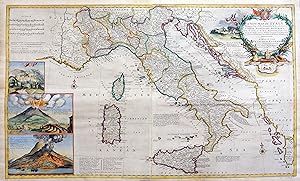
A new map of Italy
Published by Londra, 1714
Seller: libreria antiquaria perini Sas di Perini, Verona, VR, Italy
Seller rating 5 out of 5 stars
Art / Print / Poster
US$ 2,353.00
Convert currencyUS$ 45.69 shipping from Italy to U.S.A.Quantity: 1 available
Add to basketIncisione in rame, mm 600x1000, colorata a mano. Oltre alla mappa d�Italia, suddivisa negli stati dell�epoca, comprende un bel cartiglio figurato e tre riquadri con la veduta di altrettanti vulcani. L�olandese Herman Moll (1678-1732), trasferitosi a Londra come incisore, vi fond� una stamperia che al volgere del secolo divenne tra le pi? produttive e specializzate in Atlanti e mappe geografiche, spesso copiate e riprodotte dai colleghi inglesi. Bell�esemplare, con qualche strappetto restaurato e rinforzi alle giunture editoriali; qualche piega. Nr.cat: Cod 6308.
