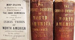
About this Item
Complete two volume set recounting the Catholic clergyman's travels as part of his missionary efforts. _____ He appears to have visited: Arkansas, Louisiana, Texas, Oklahoma, New Mexico, Arizona, California, Missouri, Kansas, Nebraska, Wyoming, Utah, Oregon, Dakota and Minnesota. _____ "A pre-1860 description of the Great Basin, the Humboldt River, Pyramid Lake (including a magnificent woodcut color sketch) is furnished in Chapter 13._____ The geographical observations are likely the earliest made by a trained European geographer._____ A very scarce book, highly readable and interesting." --Paher/Nevada 487. _____ ____WC=356.a____ Graff=1121____ Rader=1177____ Howes3=D.420.1____ Soliday=I.740 ____Field=444 ____Clark.III=305____ Flake=2973 _____ Collated and complete with all plates are present._____ Some are in full color._____ They depict landscapes, archeological artifacts and Native Americans in costume (Comanche, Zuni, Navajo, Chinook, Chippewa, Crow, Dakota, Iroquois, Mandan, Mojave, Osage, Jemez. Pueblo). _____ Also includes the color "Map Drawn / to Illustrate the Travels / & from the Documents of / The Abbe Domenech / showing / the actual situation / of the / Indian Tribes / of / North America / and the road described / by the author" (15 x 20.5", Wheat=1008)._____ The map was misfolded, has archival repairs to short edge tears and is now laid in rather than mounted. _____ Ex-library, with antique markings and rear pockets roughly removed. _____ ._____Volume one is missing the rear free endpaper._____ ._____The hinges in volume one have been reinforced, with only moderate skill._____ The spines in both volumes have been internally reinforced, apparently by the same hand. _____ ___HEAVY__VOLUME__EXTRA__POSTAGE__CHARGES__WILL__APPLY___. Seller Inventory # 02122
Contact seller
Report this item